-40%
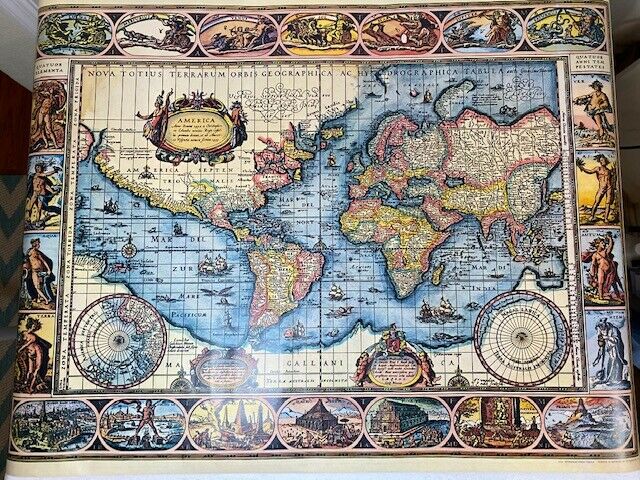
VTG Terrarum Orbis Tabula Map by W. Blaeu 1974 Scandecor Printed in Germany*Art!
$ 18.47
- Description
- Size Guide
Description
Vintage Terrarum Orbis Tabula Map by W. Blaeu 1974 Scandecor Poster Printed in Germany * Makes great Art! Such exquisite artistry. I know the listing is overkill-but art should be celebrated. Extraordinary colors and so crisp considering the tools of yesteryear.Measurements are approx: 26 3/4 inches top to bottom and 35 1/4 inches left to right. Perfectly intact and only unrolled for photographs. May not have seen the light of day since 1974!
A classic single-sheet world map on Mercator's projection
, first issued by Willem Blaeu in 1606. It remained in circulation for 50 years and is ‘celebrated as one of the supreme examples of the map maker's art’ (Shirley). This is the 4th state with ‘Terra del Fuego’ now an island, ‘Fretum le Maire’ added and the title now concludes ‘auct: Guiljelmo Blaeuw.’
Willem Blaeu.
Nova Totius Terrarum Orbis Geographica Ac Hydrographica Tabula.
Amsterdam: [1635]. Original map, fourth state. Blaeu's name Guilj. Blaeuw in the right cartouche along the bottom edge. Single sheet, two pages (18.75 x 22.375 inches; 477 x 570 mm.). Hand-colored, Roman type on verso. Three cartouches and two polar insets. Decorative boarder, vertical edges with allegorical figures, four elements on the left and four seasons on the right, horizontal edges with views of the Seven Wonders of the Ancient World on the bottom and the gods associated with the sun, moon and planets from Mercury to Saturn on the top. Paper repair to the bottom margin along the centerfold; centerfold creased; some marginal soiling with a couple small and very faint tidemarks along the bottom edge. Very good, presents nicely A
map of the world surrounded by vignettes of planets, the elements, the seasons, and the seven wonders of the ancient world, all with original hand-colored in full.
A LANDMARK MAP OF THE WORLD BY THE MOST CELEBRATED MAPMAKER OF THE 17TH CENTURY
Using Mercator's projection and first issued in 1606, this fine map remained in active circulation, for over 50 years. It is celebrated as one of the supreme examples of the mapmaker's art and in this issue, the fourth, was published in his "Atlas" from 1630 onwards. Showing both "Beach" and New Guinea as peninsulas of the great south land Terra Australis.
The most striking characteristics of Blaeu's map are the superb border decorations. Along the top are allegorical representations of the sun and moon and the five known planets, while each side has four panels illustrating the elements and the four seasons, and along the bottom are seven vignettes showing the seven wonders of the ancient world. Blaeu maps are immediately recognizable by the beauty of their ornamentation. Whereas 16th century publishers had decorated their maps with strapwork designs in black and white, Blaeu's maps were embellished with decorative swags, symbols, coats of arms, city views and large pictorial cartouches, and were handcolored in the Baroque taste.
As official cartographer to the Dutch East India Company, Blaeu had access to information regarding geographical discoveries that was unavailable to any of his competitors. Blaeu published his first world atlas, the "Atlantis Appendix", with 60 maps in 1630, and continued to produce new maps at such a rate that by 1634, he abandoned the single volume format and announced his intention to publish a new world atlas, entitled the "Theatrum", which became the most monumental cartographic publication of the 17th century. The acclaim that Blaeu's maps receive is based upon their extremely high production standards and geographical sophistication. The splendid side decoration is one of Blaeu's most recognizable decorative flourishes, and the quality of the engraving, the paper, and coloring are of the highest order, placing Blaeu's work at the forefront of seventeenth-century cartography. The maps are embellished in the Baroque style, and many - especially the world map, the centerpiece of the atlas - rank among the most beautiful ever made.
