-40%
1834 Principal Rivers Map: Courses, Countries, Lengths 11"x14" Wall Art Poster
$ 6.6
- Description
- Size Guide
Description
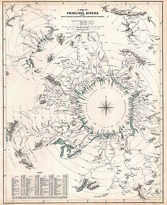
1834 Map of the Principal Rivers shewing their Courses, Countries, and ComparativeLengths.
Detailed Specifications
This is a reproduction of the original map
Print Size: 11"x14"
This Print Comes in other Sizes too:
16"x20" and 23"x28"
We have more
Charts
, you can find them in
Our Store
All Our Posters and Maps Are Made in the USA
This comparative rivers chart published in 1834 by the Society for the
Diffusion of Useful Knowledge is unique in that it imagines all of the
great rivers of the world letting out into a circular inland sea.
Concentric circles show the general lengths of the rivers as the bird files, but cannot take into account the twists and turns of the rivers themselves.
What this chart does show is, to a degree, the direction and course of the rivers' flow.
This map comes with a white border around the image
---------------------------
-How are the prints shipped?
They are rolled and placed into a rigid tube.
-Is this available in a larger/smaller size.
Yes. For smaller or larger sizes, email us.
